 |
| aerial view of the property from Historic Prince William |
Inside NOVA and several other local sources have reported
that a 20 megawatt solar farm is proposed for the Gainesville district of
Prince William County. I am a little more specific with location so that
neighbors can take a closer look.
The project identified in the planning que as Waterloo
Solar, #SUP2023-00008 Gainesville District is a Special Use Permit (SUP) request.
The property is located at 2539 Logmill
Road, Haymarket, on the north side of Logmill Road approximately ±772 feet west
of James Madison Highway (Route 15). This property is currently owned by William
and Elizabeth Latham. It was previously owned by the estate of William Latham
Sr.
The SUP is to use 125 acres out of a total ±232.26 acres for
a solar farm. They need a SUP because the property is designated as Agriculture
and Forestry, AF, and Environmental Resource Protection Overlay, ERPO, in the new
Comprehensive Long-Range Land Use Plan Map. A portion of the site lies in the
100-year Flood Hazard Overlay District and the Chesapeake Bay Act Resource
Protected Area. The surrounding areas to the north, east and west are also
designated as Agriculture and Forestry, AF, in the Long-Range Future Land Use
Map and are occupied by single family residential homes and farmland. Under the
old comprehensive plan they were all A1 zoning.
 |
| the subject property with Parnell Court to the left |
The proposed project is for the life of the solar panels, 35 years. According to the Planning department the proposed use will reduce available land for crop agriculture and could impact runoff and erosion of the land with the added access roads and land disturbance. However, the proposed site layout seen below preserves environmentally constrained areas as well as specimen trees and does not propose clearing forested areas. In addition, the applicant has proposed a possible other agricultural form of use of the land - livestock grazing in certain areas to get around the zoning issue. Mr. Latham is a farmer and grazes cows in other locations in Haymarket. (One of which is more or less behind my house.)
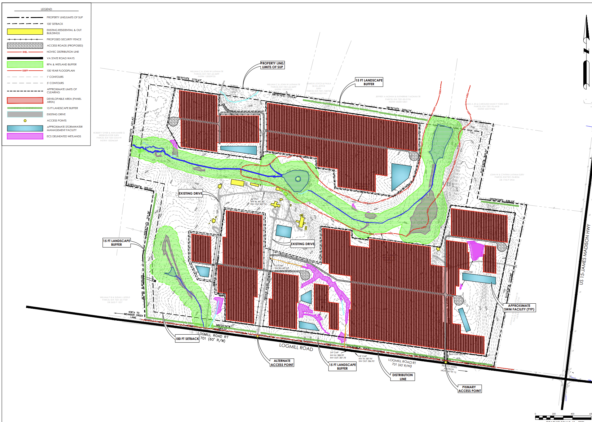 |
| from the SUP submission |
According to the Planning department “For this use to be
lawfully permitted on the subject parcel, one of the following two actions must
take place: 1. Proof of continuation of farming through a valid bona fide
agricultural use determination; or 2. Subdivide residentially used property
from residual land proposed for solar energy facility use.”
Planning has suggested several mitigations to address
concerns; however, recently Prince William County has a history of either
waving, modifying or removing mitigations at the last minute (literally at some
recent all night public hearings at dawn) so I have a certain uneasy feeling
about this.
The planning department suggests that all on-site utility
lines shall be placed underground to the extent feasible and as permitted by
the serving utility, except for the main service connection at the utility
company right-of-way and any new interconnection equipment, including without
limitation any poles, with new easements and right-of-way. The facility would
sit on 125 acres of the property and produce 20 megawatts of electricity. It
will be interconnected with the Northern Virginia Electric Cooperative grid. The
type of interconnection necessary for a power generation facility is not
discussed. Nor is there any discussion of what that will look like. This
matters, especially to the lovely homes surrounding the property and the visual
byway that Rout 15 is supposed to be.
The project would include a 100-foot setback from all
property lines and the height of solar panels would be capped at 9 feet.
However, the site restrictions read: “No aspect of the facility shall exceed 25
feet in height, as measured from grade at the base of the structure to its
highest point. Solar panels shall not exceed 13 feet in height above grade,
from the highest grade around the structure.” The planning department asks the
site developer, HCE Waterloo Solar LLC, to provide a visual assessment of the
visual impacts of the proposed solar energy system from public roadways and
adjacent properties.
Planning stipulated that "Except for motion activated safety and security lighting,
which shall be downward facing, the Facility shall not be lit. Lighting shall
not exceed fifteen (15) feet in height. Compliance shall be demonstrated on the
final site plan."
In addition, Environmental Services asks the developer to “Guarantee
to develop, implement, and maintain native vegetation to the extent practicable
pursuant to a vegetation management plan by providing native perennial
vegetation and foraging habitat beneficial to game birds, songbirds, and
pollinators. Plant buffers with vegetation that benefit pollinators and early
successional species around the boundary of the solar energy system.”
Environmental Services points out that “there are extensive RPAs throughout the parcel, but the existing conditions lack any effective vegetation. Please commit to reforesting the RPAs throughout the project area. The Riparian Buffer Guidance Manual has planting standards that should be used and referenced in a SUP Condition committing to this restoration. Staff also recommends the Applicant commit to a minimum 2-year invasive plant control period to help ensure new plantings are not overcome by non-native invasive vegetation.” This could be an important mitigation in this particularly sensitive portion of the Occoquan Watershed. It is important to make sure it actually happens.
Generally, the developer appears to be laying out the solar
arrays to avoid sensitive environmental features, but this effort needs to be
clearly demonstrated on the SUP Plan. Not empty promises that will be waived or removed at the last minute. In addition, a
stormwater management plan is very necessary for the site. Solar panels increase
stormwater velocity and this needs to be addressed.
No comments:
Post a Comment